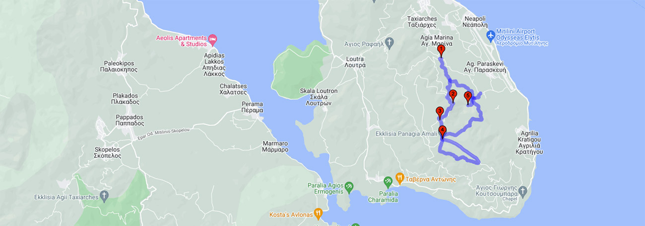
Agia Marina - Rokani - Provasma - Panagia Amali - Tsekouria - Kratigou springs - Myloi - Rokani - Agia Marina
| General description: |
The route starts from the village of Agia Marina, passes through areas with unlimited views, until it reaches the small plateau of Panagia Amalis. The descent is made through another path until it meets the city's water collection system - a real monument of hydraulic engineering - and the also interesting series of 11 water towers of the old hydro-milling system. The circle closes with a northern direction. Vegetation throughout the route consists of rough pine trees with an underfloor of phrygana. |
| Detail description: |
The closest mountain range to the island's capital is Amali. It is a mountain range that occupies the eponymous peninsula. Its pine-covered mountains, with their unique soil flora, make it an ideal place for hiking and mountain sports, and it is even the main oxygen lung of the city. The route starts from the village of Agia Marina on the eastern slopes and climbs up through the pine trees. It passes through areas with unlimited views until it reaches the small plateau of Panagia Amali with its historic chapel, built in a pine grove, and a special resting area. The descent is done by another path until it meets the city's water collection system, a real monument of hydraulic engineering, and the also interesting series of 11 water towers of the old hydro-milling system. The circle closes with a northward route, through the pine forest.
The route crosses two streams and three wooden bridges that were built for hikers to cross. At one-third of the route (starting from Agia Marina), at its highest point, there is a kiosk overlooking the island's airport, the city of Mytilene, and even Panagiouda. Further down, there is an old lake that fills up depending on rainfall.
|
| Transportation means: |
by bus or car to the settlement of Agia Marina |
| Accessibility: |
most of the route intersects with passable rural roads |
| Best season: |
Annual except of periods with heavy rainfall. |
| Places to visit: |
The site of Panagia Amali, the springs of Kratigos and the water towers, the viewing point |
| Signage: |
Yes |
| Route starting point: |
The settlement of Agia Marina at the height of the stadium |
| End of Route: |
The settlement of Agia Marina at the height of the stadium |
| Type of tourism: |
Nature-loving, walking/hiking |
Points of interest
Agia Marina
| Name: |
Agía Marína |
| Description: |
Settlement |
| Category: |
Cultural elements |
| Longitude: |
39,062716 |
| Latitude: |
26,578209 |
| Altitude: |
158 |
The temple of Agia Marina is located 5 km from the southern exit of the village. It is a three-aisled basilica building built in 1797, as indicated by the inscription above the entrance. Its dimensions are 19 X 10.50 X 6 meters. On the western side, there are two embedded marble breastplates from the Byzantine era and a plaque with the double-headed eagle. The breastplates were probably transported from the mountain of Amali and the church of Panagia located there. The temple and the throne are works of excellent woodcarving art from 1839, as indicated by the engraved date on them. (https://web.archive.org/web/20140826073855/http://agia-marina.org/agia_marina_lesvos.html)
Rokani
| Name: |
Rokani |
| Description: |
Natural landscape - view |
| Category: |
Natural landscape |
| Longitude: |
39,044016 |
| Latitude: |
26,583046 |
| Altitude: |
379 |
At one third of the way (starting from Agia Marina), at its highest point, there is a kiosk with a view of the island's airport, the city of Mytilene, and also Panagouda. The whole area consists of dense forests of rugged pine trees.
Provasma
| Name: |
Provasma |
| Description: |
Natural landscape - view |
| Category: |
Natural landscape |
| Longitude: |
39.038745 |
| Latitude: |
26.579509 |
| Altitude: |
370 |
Scenic spot within the dense pine forest with a kiosk for resting.
Panagia Amali
| Name: |
Panagia Amali |
| Description: |
Church/Monastery |
| Category: |
Cultural elements |
| Longitude: |
39,033205 |
| Latitude: |
26,579042 |
| Altitude: |
431 |
The ultimate retreat in the center of a dense pine forest on the mountain of Amali near Agia Marina. It is said that the current form of the stone-built church emerged from the foundations of an older one. The southeastern part of the church is made of limestone and inlaid bricks, while a picturesque cistern is also featured.
Kratigou springs
| Name: |
Kratigou springs |
| Description: |
Natural resources/ old technical works |
| Category: |
Natural Landscape/Monument |
| Longitude: |
39,043231 |
| Latitude: |
26,587988 |
| Altitude: |
139 |
Initially, you will encounter an imposing arch indicating that the Ottoman aqueduct used to be located there. The arch is a relic of an old watermill (water tower). There, we can observe the intricately carved stone at the top of the arch, also known as the key, as it is the stone that keeps the construction upright. Next, you will come across a paved area that constitutes the technical work of collecting water supply, which was built in 1899 with the purpose of collecting the numerous streams from the "Lagada" river gorge in the area into a central conduit that runs underneath. Previously, there were several watermills that exploited the force of the water, but after the industrial revolution, they became obsolete. Today, the conduit leads water to the water supply network of the city of Mytilene and the southern suburbs.
The route