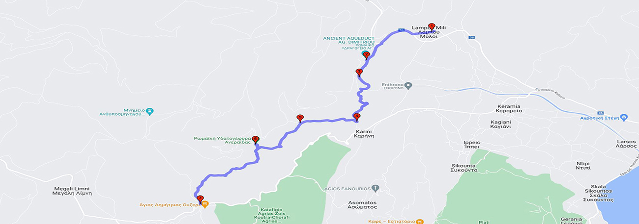
Lampou Myloi - Kamares Paspala - Enthrono - Karini - Koveli - Aneraeda - Agios Dimitrios
| General description: |
Hiking Trail connecting Lampou Myloi with Agios Dimitrios. |
| Detail description: |
The Roman Aqueduct was the most remarkable public work of antiquity on the island, with a total length of 39.5 km to Mytilene. The Hiking Trail is designed to cross, in reverse for 1/3 of its length, sections of this great monument. Starting from the village of Lamboú Myli and moving through the Lesvos olive grove, it encounters in a pine-filled valley, the largest aqueduct in the area, known as "Kamares Paspalas". Then, it goes to "Panagia sto Enthrono" with an unrestricted view of the Evgeretoula plain, the "Karinis" oasis of coolness with an inexhaustible water spring, and the cafes under large plane trees. Next, it heads towards the small valley of "Koveli" with the ancient stone bridge and, following the flow of the Evgeretoula River, reaches the "Kamara of the Fairy". The end of the route is in Agios Dimitrios, with its cafes and the famous water of the "Tsingos" spring. |
| Transportation means: |
Car and bus to Lampou Myloi and Agios Dimitrios |
| Accessibility: |
Asphalted access Lampou Myloi and Agios Dimitrios |
| Best season: |
Annually |
| Places to visit: |
The small settlement of Lampou Myloi, the traditional cafes in Karini with murals by the folk painter Theophilos, the Kamara Paspala, the Eftergetoulas Bridge in Paspala, and the area of Agios Dimitrios with its old cafes. |
| Signage: |
Yes |
| Route starting point: |
Lampou Myloi/Agios Dimitrios |
| End of Route: |
Lampou Myloi/Agios Dimitrios |
| Type of tourism: |
Walk/hike, cultural |
Points of interest
Lampou Myloi
| Name: |
Lampou Myloi |
| Description: |
Settlement |
| Category: |
Cultural element |
| Longitude: |
39,144151 |
| Latitude: |
26,404904 |
| Altitude: |
55 |
The ancient Lapie gave its name to a small village in 1548, Lambi, and while the great Roman aqueduct, after the arches of Paspalas, passed by and took water from the springs, passing through the eastern hills of the bay thousands of years later, it turned two water mills in the village of 1548, which became four later along with a water-powered olive press! And so the name "Mills of Lampi" remained! The first reference to the "water mills" of Lampi was made in 1447, under the Gatelouzos. The settlement of Lampi Mills has nice cafes for a break or meal and offers a beautiful view of the plain formed by Mt. Everageotoulas.
Enthrono
| Name: |
Enthrono |
| Description: |
Hill |
| Category: |
Viewpoint |
| Longitude: |
39,132364 |
| Latitude: |
26,397045 |
| Altitude: |
47 |
The area took its name from the ruined Byzantine chapel of Panagia Enthronos, which is located on a small hill from where the view embraces the entire plain and reaches as far as the Gulf of Geras. In Enthrono, remnants of the small village of Asrona from 1548 can be observed, which managed the waters of the springs of the western hills of the basin that flows into the area of Peukadia.
Kamares Paspala
| Name: |
Kamares Paspala |
| Description: |
Church/Monastery |
| Category: |
Cultural element |
| Longitude |
39,129451 |
| Latitude: |
26,392846 |
| Altitude: |
66 |
The so-called "Kamares" are the remaining parts of the ancient Roman aqueduct, the largest technical work of antiquity in Lesbos. There were four arches, about 20 meters high, but only two survive in relatively good condition.
Aneraeda - Anigarida
| Name: |
Aneraeda - Anigarida |
| Description: |
Bridge |
| Category: |
Cultural element |
| Longitude: |
39,116282 |
| Latitude: |
26,366234 |
| Altitude: |
120 |
The Anerragia Bridge, which takes its name from the ancient deity-nymph of the seas, rivers and lakes, Nereid. There are traces of the built base of the aqueduct, on which a later dry-stone wall was built. On the banks of the Anerragia river, there are two bases of a section of the Roman aqueduct (the arch has collapsed).
Koveli bridge
| Name: |
Koveli bridge |
| Description: |
Bridge |
| Category: |
Cultural element |
| Longitude: |
39,121895 |
| Latitude: |
26,375724 |
| Altitude: |
91 |
The river between Agios Dimitrios Agiasos and its exit from Enthronon passes through the area of Kovili, where the old Taxiarhis and remains of the Roman aqueduct are located. From Karini, the old road, which met the main road towards Kalloni, crossed the river with the beautiful bridge of Kovili. Relatively high, single-arched, it is constructed of local limestone and covered with a stone pavement. On a stone on the south side, the year 1860 is inscribed, the date it was built.
Karini
| Name: |
Karini |
| Description: |
Old industrial buildings |
| Category: |
Cultural element |
| Longitude: |
39,119145 |
| Latitude: |
26,389867 |
| Altitude: |
71 |
Amidst the lush growth of walnut and plane trees and under the thick shade of the ancient platans, visitors can find peace and relaxation, cool off in the gushing life-giving spring of cold and crystal-clear water that pours into an old Roman reservoir, dine in picturesque cafes and admire the trunk of the old plane tree where the great folk painter Theophilos Hatzimihail once lived. He painted on the external wall of a nearby building Erofili, Aretousa, Katsantonis and the Zalongo Dance. The area of Karini has been designated as a preserved natural monument with number 3801/11-8-2003 (Government Gazette 1231/B/2003) by the Directorate of Forests of the North Aegean Region.
Agios Dimitrios
| Name: |
Agios Dimitrios |
| Description: |
Settlement |
| Category: |
Cultural element |
| Longitude: |
39,102216 |
| Latitude: |
26,353334 |
| Altitude: |
201 |
Before 1900, in the area of Agios Dimitrios, approximately 25 kilometers from the city of Mytilene, two related families opened two shops on plots of land belonging to them, on the road that connected the city of Mytilene with Polichnitos. Given the absence of cars, the journey from Mytilene to Polichnitos by horses and mules took two full days. For this reason, the presence of two points almost halfway through the route, where travelers to Polichnitos, Vatera, Vasilika, and the surrounding areas could rest and be offered food, water, coffee, and the possibility of overnight stay was very useful.
The route