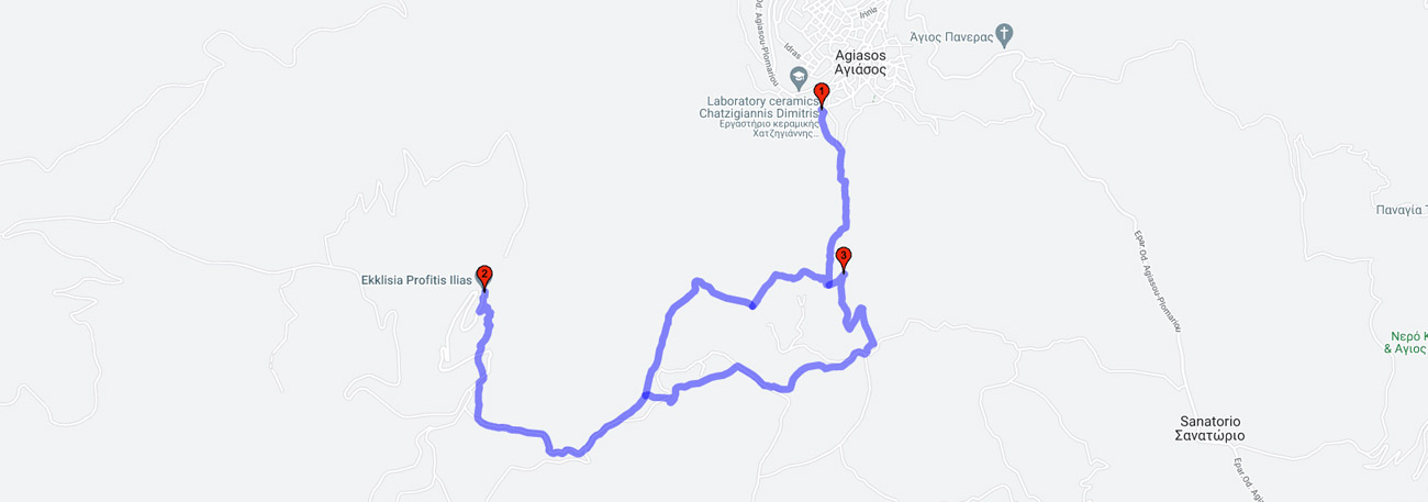
Agiasos (Iroon) - Kameno Aloni - Marmaro - Olympos peak - Marmaro - Patsavoura - Agiasos (Apesos)
| General description: |
Hiking trail within rural landscapes and forested areas with pine trees, cultivated olive groves, chestnut trees, fir trees, and orchids. |
| Detail description: |
Opposite the Heroon of Pesonton (at the southern entrance of the village) begins the paved path that crosses the orchards of the "Folidi - Kadi Vrysi" area, climbs up to the chestnut trees of the "Milandra" area and meets the rural road at the "Kameno Aloni" location. The road to the right is a dead end, but it meets the path at the "Marble" location, which climbs to the rocky peak of Olympus. Pine forest, chestnut trees, woody forms of holm oaks, and a variety of deciduous shrubs cover the slopes of Mount Olympus. The lower hills are occupied by the olive groves of Lesvos, while the entire area is home to a variety of herbs and wildflowers, including rare and protected species. The solid bulk of the peak stands out bare, making the mountain distinguishable from a great distance, and the view towards large parts of the island is unlimited. This mountainous area has been included as a protected area in the NATURA 2000 Network. It is a unique experience to hike on every path of Olympus, paved or dirt, but by choosing to climb to the peak of Prophet Elias (the highest peak of the island, 967 m. along with Lepetymnos), the Network Trail passes the hiker through the most important paved areas of the region, the productive chestnut grove, the dense shrubland, and the special "sara" of limestone for the peak. |
| Transportation means: |
Car and bus to Agiaso |
| Accessibility: |
Asphalted access to Agiasos and to the base of Prophet Ilias, connection to rural roads |
| Best season: |
Annually |
| Places to visit: |
The folklore collections of Agiassou, the church of Panagia Agiassos |
| Signage: |
Yes |
| Route starting point: |
Agiasos |
| End of Route: |
Agiasos |
| Type of tourism: |
Nature-loving, walking/hiking |
Points of interest
Agiasos (Iroon)
| Name: |
Agiasos (Iroon) |
| Description: |
Settlement |
| Category: |
Cultural elements |
| Longitude: |
39,080558 |
| Latitude: |
26,371542 |
| Altitude: |
400 |
Agiasos was created where the monk Agathon the Ephesian built his hermitage. He came from Jerusalem to Lesbos during the time of the Iconoclasm (803 AD) with an Icon of the Virgin Mary and other sacred relics. According to the current view, the name of the village comes from the inscription on the Icon of the Virgin Mary that Agathon brought from Jerusalem, "MOTHER OF GOD HOLY ZION". Agiasos is characterized as a traditional settlement with the designation of an urban settlement by Presidential Decree (19.10/13-11-1978, Government Gazette 594/D/13-11-1978). Its character is urban (continuous building system) and yards are completely absent or very few. The settlement develops around the Church of Panagia, to which all the main roads lead. As they converge towards the center from the periphery of the village, they meet at acute angles which is a characteristic element of Agiasos. The cultural collections of Agiasos that are hosted in the Folklore Museum are noteworthy.
Olympos peak
| Name: |
Olympos peak |
| Description: |
Peak |
| Category: |
Viewpoint |
| Longitude: |
39,073519 |
| Latitude: |
26,354035 |
| Altitude: |
968 |
The peak, made of limestone, is bare. From here one can admire a magnificent view towards the beautiful Agiasos. Mount Olympus is a forested mountain with large forests of rugged pine trees. In some places one can find few clusters of black pine and near Agiasos lies the famous Kastaniona of the island. The region of Olympus is a botanical paradise as it contains many unique species. At the summit one can find one of the rarest and most beautiful orchids, the Himantoglossum comperianum, which grows only here and on the island of Samos in all of Greece. Many rare species grow on the bare peaks and rocks, such as the island endemics Alyssum xiphocarpum and Alyssum lesbiacum, the tea plant Sideritis sipylea, Silene urvillei, Microsciadium minutum, Paeonia mascula subsp. Mascula, Aethionema saxatile subsp creticum, Astragalus angustifolius subsp. Aegeicus, Veronica grisebachii, Centaurea urvillei subsp. Urvillei, Viola heldreichiana, Geocaryum stylosum, Minuartia anatolica, Minuartia mesogitana, Origanum onites and Aubrieta deltoidea.
Patsavoura
| Name: |
Patsavoura |
| Description: |
Natural spring |
| Category: |
Rest point |
| Longitude: |
39,074116 |
| Latitude: |
26,371659 |
| Altitude: |
598 |
A location with a source of drinking water that flows all year round and exceptional vegetation.
The route