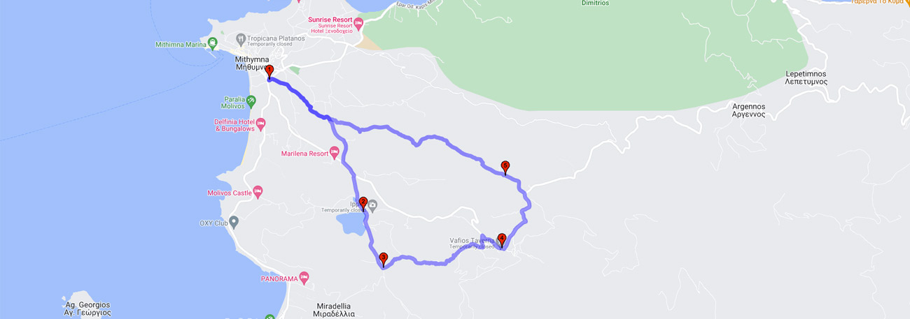
Molyvos - Limnodeksameni - Mixes - Vafios - Agios Ioannis - Molyvos
| General description: |
Hiking trail from Molivos to Vafeio and return via Agios Ioannis. |
| Detail description: |
The hiking trail moves away from the urban fabric of the traditional settlement, through the olive groves of the plain. A short stop at Agia Rodotou, an open shrine on a rocky formation, and at the Methymna Reservoir, a little further. Then, an uphill climb on a path, under the shade of tall pine trees and next to dry stone walls. Vafeios, with its small two-story stone houses, has windows facing Molivos and the field of low hills, while the Aegean Sea and the Anatolian coasts of Troada stretch out in the distance. It is worth wandering through the cobbled streets with cool springs and hidden courtyards overflowing with wild climbing plants and intoxicating fragrances. Return to Molivos through Agios Ioannis in free pastures, with a view of the small town and the medieval castle. |
| Transportation means: |
Car and bus to Molivos and Vafeio. |
| Accessibility: |
Paved access to Molyvos, Vafeio, and Agios Ioannis, connected to rural roads. |
| Best season: |
Spring, Autumn |
| Places to visit: |
|
| Signage: |
Yes |
| Route starting point: |
Mólyvos (Mýthimna) |
| End of Route: |
Mólyvos (Mýthimna) |
| Type of tourism: |
Nature-loving, walking/hiking |
Points of interest
Molyvos
| Name: |
Molyvos |
| Description: |
Settlement |
| Category: |
Cultural elements |
| Longitude: |
39.365592 |
| Latitude: |
26.177347 |
| Altitude: |
12 |
Molyvos is one of the most beautiful traditional and preserved settlements not only in Lesvos but also in the entire Aegean. Its well-preserved castle and its uphill narrow alleys with the grand houses are just some of the characteristics that captivate its visitors. The unique view of the Aegean as you stand in front of the castle entrance, the picturesque little harbor at the edge of the settlement, the quaint shops with well-dressed windows, and the smells from the dishes offered by the taverns and ouzo bars complete the picture.
Limnodeksameni
| Name: |
Limnodeksameni |
| Description: |
Reservoir |
| Category: |
Nature |
| Longitude: |
39.346159 |
| Latitude: |
26.195634 |
| Altitude: |
85 |
The area of the water tank offers a beautiful view of the surrounding area, which is composed of agricultural crops. The water tank is used as a resting stop for migratory birds.
Mixes
| Name: |
Mixes |
| Description: |
Viewpoint |
| Category: |
View |
| Longitude: |
39.338816 |
| Latitude: |
26.198505 |
| Altitude: |
107 |
From this point, the hiker has an excellent view towards Molivos and Petra.
Vafios
| Name: |
Vafios |
| Description: |
Settlement |
| Category: |
Cultural elements |
| Longitude: |
39.341029 |
| Latitude: |
26.221444 |
| Altitude: |
300 |
The village is located on the slopes of Mount Lepetymnos. In fact, parts of the mountain's rocks, which due to seismic vibrations over the centuries began to detach, have been restored and held in place by huge chains. These stone masses are called "Rachta" by the locals.
According to tradition, the village derives its name from the tanneries (leather dyers) that once operated in the area. Of course, there are also the romantic theorists, who argue that the name comes from the deep red color that spreads over the village at sunset on Lesvos. Right in the center of the village dominates the church of Agia Paraskevi, whose wood-carved iconostasis is still preserved, even if the signs of time are visible.
Agios Ioannis
| Name: |
Agios Ioannis |
| Description: |
Chapel / Viewpoint |
| Category: |
Nature |
| Longitude: |
39,351837 |
| Latitude: |
26,220317 |
| Altitude: |
293 |
A small grove with a stream of potable water can offer the hiker a view of the surrounding hills covered with scrub vegetation as well as sparse oak trees.
The route