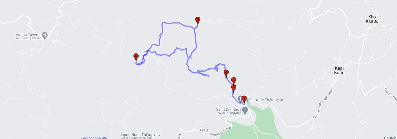
Pelopi - Myloi - Monoplatanos - Ano Kampos - Profitis Ilias peak - Kolaftos peak - Vígla peak - Ano Kampos - Myloi - Pelopi
| General description: |
The Trail to the peaks starts from Pelopi. After the ‘oasis’ at the Myloi location with the large cistern, the climb continues on the slopes along the cool stream until, after Monoplatanos, Lepetymnos reveals. After Vigla (the highest peak of the island at 968m) the Trail continues almost on the ridgeline and passing from ‘tou Kolaftou ta Rahta’ (The rocks of the peak) it arrives at the Profitis Ilias Peak with the chapel built at the summit of a solid rock (volcanic cupola). |
| Detail description: |
The Trail to the peaks starts from Pelopi, built on either side of a ragging torrent of Mount Lepetymnos. After the ‘oasis’ at the Myloi location with the large cistern, the climb continues on the slopes along the cool stream until, after Monoplatanos, Lepetymnos reveals its harsh side. Steep slopes studded with boulders but also spots for breathers with small plateaus and resilient oak trees with mosses and lichens. The whole mountain area is volcanic which becomes more apparent at higher altitudes and at the rocky, often stormy summits. On a clear day the horizon offers a stunning view all around. After Vigla (the highest peak of the island at 968m) the Trail continues almost on the ridgeline and passing from ‘tou Kolaftou ta Rahta’ (The rocks of the peak) it arrives at the Profitis Ilias Peak with the chapel built at the summit of a solid rock (volcanic cupola). |
| Transportation means: |
by car or bus to Pelopi |
| Accessibility: |
The path intersects at points with rural roads. At the top Prof. Ilias is reached by a rural road of moderate - poor passability. |
| Best season: |
Spring, autumn |
| Places to visit: |
Stone bridge in the cemetery, ruins of water mills, folklore collection in the old school. |
| Signage: |
Yes |
| Route starting point: |
The village of Pelopi |
| End of Route: |
The village of Pelopi |
| Type of tourism: |
Nature-loving, walking/hiking |
Points of interest
Pelopi
| Name: |
Pelopi |
| Description: |
Settlement |
| Category: |
Cultural elements |
| Longitude: |
39,3238028114 |
| Latitude: |
26,2788090283 |
| Altitude: |
388 |
Pelopi is built on the slopes of Mount Lepetymnos, full of trees and water, picturesque stone-paved alleys made of hewn stone or simple stones that were once the primary building material for the houses. Its name, Pelopi, was taken from Pelops, son of the King of Phrygia in Asia Minor, who passed through Lesbos before the Trojan War on his way to participate in the games organized by the King of Mycenae and deceitfully took over the throne there, giving his name to the Peloponnese. It is worth visiting the stone bridge in the cemetery. It is a beautiful landscape with many trees around, creating a delightful coolness, the water that runs there is always cool and it is the best for someone who wants to try water from a natural source. The bridge crosses the Kotzina tributary of the Tsiknia River.
Ydromylos
| Name: |
Ydromylos |
| Description: |
Industrial ruins |
| Category: |
Cultural elements |
| Longitude: |
39,3284674454 |
| Latitude: |
26,2781643961 |
| Altitude: |
379 |
The water towers and the ruins of the flour mills are the remains of the village's industrial era, while the water reservoir of the watermill just outside the village on the route is an oasis of greenery and freshness.
Monoplatanos
| Name: |
Monoplatanos |
| Description: |
Rest point |
| Category: |
Natural landscape - view |
| Longitude: |
39.3302491866 |
| Latitude: |
26.2782974169 |
| Altitude: |
370 |
A place of relaxation and freshness with large plane trees and rich lush vegetation.
Bekiri waterfall
| Name: |
Bekiri waterfall |
| Description: |
Rest point |
| Category: |
Waterfall |
| Longitude: |
39,33243007 |
| Latitude: |
26,276009074 |
| Altitude: |
500 |
The Kotzinas stream forms two small waterfalls in Pelopi, one near the Bekiri area along the road and the other south of the settlement near Psirado. The Bekiri waterfall is a hidden beauty of the area.
Profitis Ilias
| Name: |
Profitis Ilias |
| Description: |
Peak |
| Category: |
Viewpoint |
| Longitude: |
39,309643 |
| Latitude: |
26,268485 |
| Altitude: |
932 |
Unlimited view of the whole island and the small beaches of Asia Minor, perhaps the most demanding climb on all the routes of the island.
Vígla
| Name: |
Vígla |
| Description: |
Peak |
| Category: |
Viewpoint |
| Longitude: |
39,310092 |
| Latitude: |
26,268836 |
| Altitude: |
969 |
Unlimited view of the whole island and the small beaches of Asia Minor, perhaps the most demanding climb on all the routes of the island.
The route