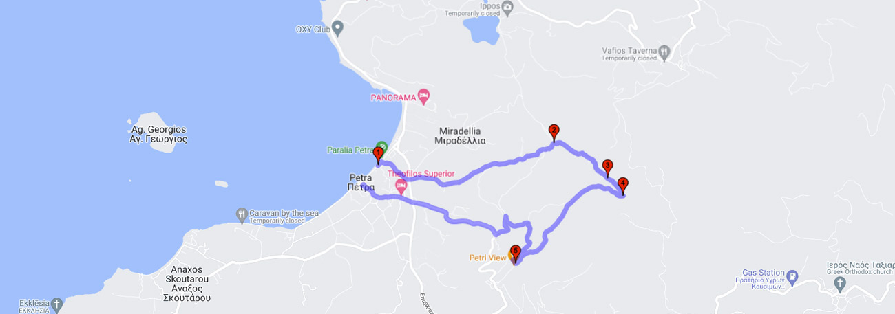
Petra - Agia Fotini - Ydromyloi - Pigi Ligona - Monastirelia - Petri - Achilliopigada - Petra
| General description: |
Hiking trail starting at Petra through cultivated olive groves, agricultural land with grasslands, riparian vegetation and plane trees, forested areas with a variety of oak trees, and shrubs. |
| Detail description: |
The rural area of Petra, with its fertile plain, had the advantage of self-sufficiency in grinding the produced grains from ancient times. The perennial flow of the Ligonas source supplied a series (17) of mills, whose water towers now stand as witnesses of the pre-industrial past and monuments of the architectural heritage of the island. The route passes through the chapel of "Agia Fotia" and climbs towards the Ligonas stream, which is of particular geomorphological interest, crossing small millstone paths next to the ruined water mills. After visiting the source, the route is completed by climbing to the old chapel of Agios Dimitrios in the Monasterelia area, getting to know this particular valley. Returning to the small Petra, offers an unlimited view of the Petra plain, with its small islands and the open Aegean Sea. Descending from the area of Achilleiopigada, the hiking circuit ends under the rock of Panagia, in the square. |
| Transportation means: |
Car and bus to Petra |
| Accessibility: |
Asphalted access to Petra and Petri, connection to rural roads |
| Best season: |
Spring, Autumn |
| Places to visit: |
The Virgin Mary of Petra, the Mansion of Vareltzidaina (1800), and the Church of St. Nicholas (1640). |
| Signage: |
Yes |
| Route starting point: |
Petra |
| End of Route: |
Petra |
| Type of tourism: |
Nature-loving, walking/hiking, historical, recreational. |
Points of interest
Petra
| Name: |
Petra |
| Description: |
Settlement |
| Category: |
Cultural elements |
| Longitude: |
39.327513 |
| Latitude: |
26.175223 |
| Altitude: |
2 |
The town of Petra is full of well-preserved neoclassical mansions from the 19th and 20th centuries, with lush courtyards, ornate doors, and beautiful lintels. Of particular interest is the recently restored mansion of Vareltzidaina (located a short distance from the central square), which is considered unique in Lesvos for its internal layout and beautiful wall paintings. A characteristic feature is the approximately 40-meter high rock that dominates the area, and on top of which the church of Panagia Glykofilousa is built.
Agia Fotini
| Name: |
Agia Fotini |
| Description: |
Church/Monastery |
| Category: |
Cultural elements |
| Longitude: |
39.331601 |
| Latitude: |
26.211124 |
| Altitude: |
86 |
Agia Fotini Or "Agia Fotia". A small chapel built in the 18th century, appears to be the church of the abandoned settlement of the millers.
Ydromyloi Ligóna
| Name: |
Ydromyloi Ligóna |
| Description: |
Ruins of Watermills |
| Category: |
Cultural elements |
| Longitude: |
39.326981 |
| Latitude: |
26.212139 |
| Altitude: |
170 |
18 watermills complex, constructed in the 18th century, indicate the existence of the settlement of "Myolnades" through their ruins. The settlement and the watermills are connected to Petra, Petri, and Stypsi through paved paths. The watermills were built along the waterway of Ligonas and its millstream, whose construction is mostly preserved. Additionally, several water towers are preserved along the entire route. Water passes from one watermill to the other with the help of the millstream until it reaches the plain of Petra.
Monastirellia - Agios Dimitrios
| Name: |
Monastirellia - Agios Dimitrios |
| Description: |
Rest point |
| Category: |
Cultural elements |
| Longitude: |
39.326384 |
| Latitude: |
26.213597 |
| Altitude: |
257 |
In the area, one can find the small chapel of Agios Dimitrios, built in the early 18th century, as well as the "water-mana" and the first two water mills, which may be constructions predating 1800.
Petri
| Name: |
Petri |
| Description: |
Settlement |
| Category: |
Cultural elements |
| Longitude: |
39.318911 |
| Latitude: |
26.198027 |
| Altitude: |
214 |
Returning, we come across the village of Petri, a small settlement with a great view of the plain and the sea area of Petra. Further down, we pass through the location of Achilleiopigado, where it is rumored that Achilles stopped to supply water on his way to Troy.
The route