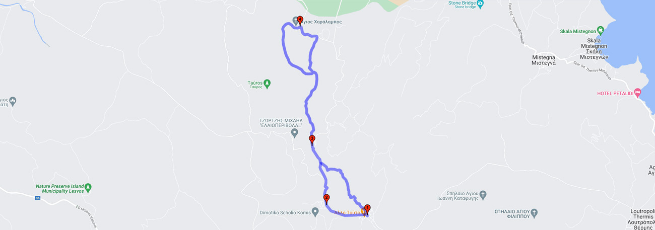
Pigi - Panagiouda - Paliochori - Taurus Plateau - Agios Charalambos - Paliochori - Komi - Pigi
| General description: |
From the village of Pigi towards the plateau of "Tauros". The first stop is at Panagouda, and then a route passing through the Old Village, the site of an old settlement, leads to the popular chapel of Agios Charalambos. The return is made by the same path but at the location of Paliochori, the route branches south towards the village of Komi and from there back to Pigi. |
| Detail description: |
From the village of Pigi, the ascent to the series of plateaus named "Tauros" begins, starting with the first and most representative one, that of Agios. The first stop is at Panagouda, followed by a path that passes through Paliochori, the site of an old settlement, with a small spring. The route runs parallel to the stream and becomes more uphill through an olive grove with stone steps. The olive trees are replaced by pine trees until the cliffs made of ignimbrite rock, which make up the plateau, emerge. The level of formation is revealing. On the rocky ground, among wind-swept pines and massive rocks, the path of the route leads to the popular chapel of Agios Haralambos, in the eastern plain. The area is connected with important religious celebrations for the island.
The return is made on the same path, but at the location of Paliochori, the route branches off to the south towards the village of Komi and from there back to Pigi.
|
| Transportation means: |
By bus or car to the village of Pigi |
| Accessibility: |
A large part of the route is a path. A rural road also reaches the Tavros plateau. A small part of the route from Komi to Pigi is on a municipal road. |
| Best season: |
Annually |
| Places to visit: |
Pigi, Panagiouda, Agios Charalampos, Komi |
| Signage: |
Yes |
| Route starting point: |
Pigi |
| End of Route: |
Pigi |
| Type of tourism: |
Nature-loving, walking/hiking, religious. |
Points of interest
Pigi
| Name: |
Pigi |
| Description: |
Settlement |
| Category: |
Cultural elements |
| Longitude: |
39,182068 |
| Latitude: |
26.199694 |
| Altitude: |
156 |
Typical traditional rural settlement, built around 1780, is traversed by the Tenea stream. The large compact section of the settlement climbs up the slope on the north bank of Tenea, and a small cluster of buildings is located further east on the south bank of the stream. In this settlement, the meeting point of the residents is the small sloping square from which the provincial road to Komi passes, with the plane tree in the center and around it the church, shops, and cafes. In Pigi, the paved square and narrow alleys offer unique hospitality and impressive walks to visitors.
Panagiouda
| Name: |
Panagiouda |
| Description: |
Abandoned settlements |
| Category: |
Cultural elements |
| Longitude: |
39,195425 |
| Latitude: |
26,403861 |
| Altitude: |
217 |
This is a small chapel in the shade of a large plane tree where you can fill your containers with drinking water from its fountain.
Agios Charalampos
| Name: |
Agios Charalampos |
| Description: |
Church/Monastery |
| Category: |
Cultural elements |
| Longitude: |
39,218337 |
| Latitude: |
26,399602 |
| Altitude: |
286 |
The tradition of the couples refers to the festival that takes place at the chapel of Saint Charalambos, in the enchanting mountainous location of Tauros. With this celebration, the unchanged, long-standing tradition of the couples who honored their patron saint, Saint Charalambos, with particularly impressive events, reaches our days. On Friday morning, the bull is led, to the sounds of traditional music, in front of the house of the "first couple," the president of the Cultural Society that organizes the festival, or the "donor," the one who provided the money to buy the animal. The decoration of the animal begins with the most beautiful flowers of the Lesbos land. A procession is formed behind the banners and the musical bands, and the procession of the image of the "Elder," as the locals call Saint Charalambos, begins. The procession starts from the Pigi Square, passes through the village of Komi and ends again at Pigi. The "rahmani" follows, equestrian races in the circular racetrack.
Komi
| Name: |
Komi |
| Description: |
Settlement |
| Category: |
Cultural elements |
| Longitude: |
39,183652 |
| Latitude: |
26,407305 |
| Altitude: |
183 |
Before the population exchange that followed the Greco-Turkish War, the population in Komi was purely Turkish. Buildings that date back to that era include the mosque, the old olive press, and the spring known as the fountain of Pechlivandos, which attract the attention of visitors.
The route