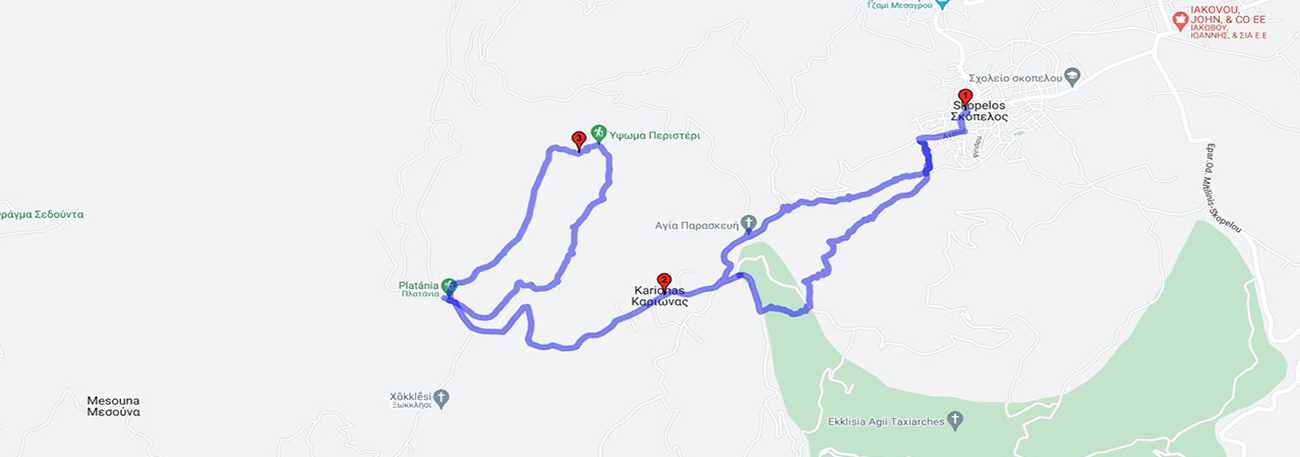
Skopelos- Karionas - Peristeri - Karionas – Skopelos
| General description: |
Circular Hiking Trail of Skopelos Gerakas and Karyona |
| Detail description: |
A trail that leads from Skopelos, the southernmost and highest village of Geras, to rural locations, the highest points of Geras and above the olive groves. The area of Karyona stretches out on a plateau surrounded by pine trees, divided into small estates with orchards and few holiday homes. To the north stands the calcareous hill of Peristeri. The ascent to its peak rewards the hiker with an unparalleled view and unique flora. The trail begins from the location of Platania on the rural road, 2 km west of the start of Karyona. The flat summit, during the flowering season of various plants, offers pleasant surprises. The descent follows a different route, following the signs, but still ends up in Platania. The descent to the village follows another route (Agia Paraskevi), but ends up in the center of Skopelos with its cool springs. |
| Transportation means: |
Car and bus to Skopelos |
| Accessibility: |
Asphalted access to Skopelos |
| Best season: |
Annually |
| Places to visit: |
The square of Skopelos, the church of Agia Magdalini of 1925 with the catacombs, and the church of Agios Georgios built in 1905. |
| Signage: |
Yes |
| Route starting point: |
Skopelos Geras |
| End of Route: |
Skopelos Geras |
| Type of tourism: |
Nature-loving, walking/hiking |
Points of interest
Skopelos
| Name: |
Skopelos |
| Description: |
Settlement |
| Category: |
Cultural element |
| Longitude: |
39,029132 |
| Latitude: |
26,447072 |
| Altitude: |
148 |
The first references to the settlement of Skopelos date back to 1125 BC. In the large and cool square of Skopelos, the marble fountain made of blue local marble has been standing there since 1813 and is worth seeing. Also, the spring in the lower market of Skopelos, built-in 1911 with marble from Taslik, is worth a visit. Skopelos is also known for the "Magdalene's rabbits", the large Christian catacombs located beneath the temple of Saint Magdalene, which lead to Agiasma.
Karionas
| Name: |
Karionas |
| Description: |
Plateau |
| Category: |
Viewpoint |
| Longitude: |
39,020463 |
| Latitude: |
26,431102 |
| Altitude: |
469 |
The plateau of Karyona is characterized by scattered summer houses of the prominent Skopelos residents, who used to go up there for the summer or "cohabitate" with the local dialect after the feast of Agia Magdalini until the end of August. The area offers exceptional views towards the Gulf of Geras, is a point with rich flora and fauna, and there is a taverna for a refreshing stop or meal.
Peristeri
| Name: |
Peristeri |
| Description: |
Hill |
| Category: |
Viewpoint |
| Longitude: |
39,025401 |
| Latitude: |
26,425864 |
| Altitude: |
647 |
The hill of Peristeri on the western side of the Gulf of Gera offers uninterrupted views of the Gulf of Gera, as well as the areas of Plomari and the reservoir of X. Sedounta.
The route